River Processes and Landforms

Aligned to the AQA 8035 specification
- Level
- Intermediate
- Reading time
- 16 min
- Published
- 10 June 2026
- Updated
- 25 August 2026
On this page
Key takeaways
- River velocity is highest in the lower course, not the upper course: although the gradient flattens, the wider, deeper, smoother channel reduces friction so velocity increases, and discharge rises as tributaries join.
- Waterfalls retreat by undercutting: a resistant cap rock overlies softer rock that erodes faster, the overhang collapses, and the fall retreats upstream leaving a gorge of recession, as at High Force on the Whin Sill.
- On a meander, erosion (river cliff) occurs on the faster outer bank, while deposition (slip-off slope or point bar) occurs on the slower inner bank.
- An oxbow lake forms when the narrow neck of a very tightly curved meander is cut through during a flood, and the abandoned loop is sealed off by deposition.
- Floodplains are built upward by repeated deposition of fertile alluvium during floods, not only by lateral erosion, which is why floodplain soils are so fertile.
The Long Profile and Changes Downstream
A river's long profile plots the gradient (steepness) of the riverbed from source to mouth. It is typically concave — steep in the upper course and more gradual in the lower course — as the river works to achieve a smooth equilibrium gradient called the graded profile. The diagram below shows the concave shape and where each course sits along it.
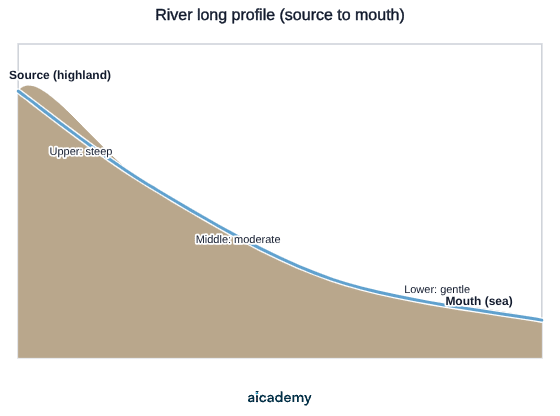
Changes along the long profile:
| Characteristic | Upper course | Middle course | Lower course |
|---|---|---|---|
| Gradient | Steep | Moderate | Gentle |
| River velocity | Slow (rough, narrow channel) | Moderate | Fastest (smooth, wide channel) |
| Discharge | Low | Increasing | Highest |
| Channel width and depth | Narrow and shallow | Wider and deeper | Widest and deepest |
| Sediment size | Large, angular boulders | Mixed: cobbles to gravel | Fine sand, silt, and clay |
| Dominant process | Vertical (downward) erosion | Lateral (sideways) erosion and transportation | Transportation and deposition |
| Typical landforms | Interlocking spurs, V-shaped valley, waterfalls | Meanders beginning | Meanders, floodplains, levées, oxbow lakes |
An important misconception to correct: river velocity does not decrease from source to mouth. Although the gradient flattens, the channel becomes much smoother, wider, and deeper downstream, reducing friction — so velocity actually increases overall despite the gentler gradient. Discharge increases as tributaries add water.
Upper Course Landforms
V-shaped valleys and interlocking spurs: In the upper course, vertical erosion cuts downward, forming a steep-sided V-shaped valley. Hard rock ridges called interlocking spurs alternate on either side of the valley, forcing the river to wind between them. The valley sides are steep because rainwater and mass movement continually add material to the river, which cuts deeper rather than widening its channel.
Waterfalls and gorges:
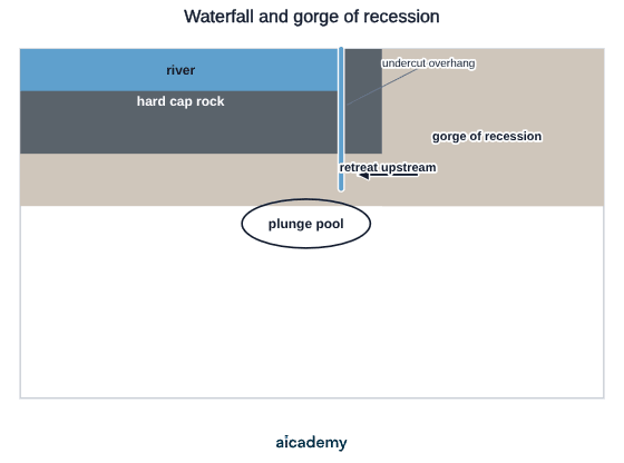
- A river flows over a band of resistant rock (e.g. dolerite, sandstone) overlying softer rock (e.g. shale, mudstone)
- The softer rock below erodes more quickly; a step forms
- Hydraulic action and abrasion cut a plunge pool at the base of the fall through the force of the falling water and swirling boulders (pothole drilling)
- The softer rock undercuts the hard cap rock, leaving it overhanging
- The overhang collapses (undercutting + crack widening); the waterfall retreats upstream
- A gorge of recession marks the previous positions of the waterfall — a steep-sided, narrow valley cut by the retreating fall
The cross-section below shows the key features examiners look for: the resistant cap rock, the undercut overhang, the plunge pool, and the gorge left behind as the fall retreats upstream.
UK example — High Force, Upper Teesdale (County Durham):
- One of England's largest waterfalls (21 m drop)
- The Whin Sill (resistant igneous dolerite) overlies soft Carboniferous limestone/shale
- The gorge behind High Force is approximately 500 m long, representing the distance the waterfall has retreated since the last ice age
- The plunge pool is clearly visible at low flow
Something not quite clicking?
Ask Aica to explain any part of this differently. Free, takes 30 seconds.
Key terms
- Hydraulic action
- Erosion by the force of the water itself, where compressed air in cracks explodes as water retreats, widening joints and fractures.
- Abrasion (corrasion)
- Erosion where sediment carried by the river scrapes and grinds the channel bed and banks.
- Attrition
- Erosion where rocks and pebbles carried by the river collide and become progressively smaller, rounder and smoother.
- Solution (corrosion)
- Erosion where slightly acidic water dissolves soluble minerals in rock, such as calcium carbonate in limestone, removing material in chemical solution.
- Long profile
- A plot of the gradient of a riverbed from source to mouth, typically concave: steep in the upper course and gradual in the lower course.
- Interlocking spurs
- Hard rock ridges that alternate on either side of an upper-course V-shaped valley, forcing the river to wind between them.
- Gorge of recession
- A steep-sided, narrow valley cut by a waterfall as it retreats upstream, marking the fall's previous positions.
- Meander
- A bend in a river where erosion forms a river cliff on the outer bank and deposition forms a point bar (slip-off slope) on the inner bank.
- Oxbow lake
- A horseshoe-shaped body of water formed when the neck of a tightly curved meander is cut through during a flood and the old loop is sealed off by deposition.
- Levée
- A natural raised bank of coarse sediment built up on either side of the channel by repeated deposition when the river overtops its banks during floods.
- Floodplain
- The wide, flat valley floor either side of the channel in the lower course, built up by repeated deposition of fine alluvial sediment during floods.
- Estuary
- The wide, funnel-shaped mouth of a river where it meets the sea and is influenced by tidal action, forming mud flats and salt marshes.
Frequently asked questions
A river flows fastest in the lower course. Although the gradient is steeper in the upper course, the channel there is narrow, shallow and rough so friction slows the water. In the lower course the channel is wide, deep and smooth, reducing friction so velocity increases, and discharge rises as tributaries add water.
A river flows over resistant cap rock overlying softer rock. The softer rock erodes faster, and hydraulic action and abrasion cut a plunge pool. The cap rock is undercut, overhangs and collapses, so the fall retreats upstream, leaving a steep-sided gorge of recession, as behind High Force (about 500 m long).
An oxbow lake forms when a meander becomes very tightly curved, and during a flood the river cuts straight through the narrow neck of land, taking the shortest, steepest path. Deposition seals off each end of the old loop, leaving an abandoned curve of water that gradually silts up into marshy wetland.
Generate revision on any topic you study
Type any topic you're studying and Aicademy generates a complete lesson, quiz, and flashcard set, personalised to your level.
Lessons on anything
Structured, level-matched lessons on any topic you study
Practice quizzes
Find out what you actually know before the exam does
Flashcard sets
Lock in key concepts with instant revision cards
Ask Aica
Stuck on something? Get a clear explanation, any time
River Flooding: Causes and Management
The Development Gap: Causes and Strategies
Related lessons
11 min
UK Physical Landscapes: Uplands, Lowlands and River Systems
GCSE Geography · AQA 8035
4 months ago