Track progress, take quizzes and save notes on this lesson.

Free forever · no card needed

Start free
Foundational

UK Physical Landscapes: Uplands, Lowlands and River Systems

AicademyAicademy
·GCSE Geography
3.1.3.1 UK physical landscapes

Aligned to the AQA 8035 specification

Level
Foundational
Reading time
10 min
Published
10 June 2026
Updated
1 July 2026
On this page
  1. 1.The Shape of the UK: Upland and Lowland Britain
  2. 2.Major Upland Areas of the UK
  3. 3.Major Lowland Areas of the UK
  4. 4.UK River Systems: Drainage Basins and Major Rivers
  5. 5.Upland vs Lowland: A Comparison
  6. 6.Common Exam Mistakes

Key takeaways

  • Upland Britain (typically above 200 m) lies in the north and west on older, harder rocks, while lowland Britain (below 200 m) dominates the south and east on softer sedimentary rocks.
  • The Severn is the UK's longest river at 354 km; the Thames (346 km) is the longest river entirely within England, and the Tay is Scotland's longest.
  • A drainage basin is the area of land drained by a river and its tributaries, bounded by a watershed; the Pennines form the main watershed of northern England.
  • A river's source is where it begins in upland areas and its mouth is where it reaches the sea, so the Severn's source is Plynlimon and its mouth is the Bristol Channel.
  • The upland-lowland divide is not a strict north-south line: the Scottish Central Belt and Vale of York are northern lowlands, while Dartmoor is an upland in southern England.

The Shape of the UK: Upland and Lowland Britain

The United Kingdom's physical landscape is strikingly varied, shaped by hundreds of millions of years of geological change and, more recently, by glaciation during the last ice age (~12,000 years ago). The most fundamental contrast is between upland and lowland Britain.

The general pattern:

  • Upland areas (typically above 200 m) concentrate in the north and west: Scotland, Wales, and northern England
  • Lowland areas (typically below 200 m) dominate the south and east: the Midlands, East Anglia, and the Thames Basin

Why does this pattern exist?

  • Older, harder, more resistant rocks — granite, gritstone, and ancient metamorphic rocks — underlie the uplands and resist erosion
  • Younger, softer sedimentary rocks — chalk, clay, and limestone — underlie the south and east and have been worn down to low relief over millions of years
  • Ice sheets during the last glaciation (the Devensian) reshaped the uplands, carving U-shaped valleys and depositing material across lowland areas

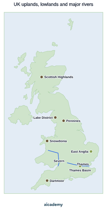
The map below shows the broad split: resistant uplands in the north and west, softer lowlands in the south and east, with the major rivers draining between them.
Section C of Paper 1 examines three types of UK landscape — coastal, river, and glacial — and students answer any two. Understanding the overall pattern of UK relief provides the context for all three.

Major Upland Areas of the UK

The UK's principal upland regions are concentrated in Scotland, Wales, and northern and south-western England.

Upland areaLocationKey physical features
Scottish HighlandsNorthern ScotlandUK's highest peaks including Ben Nevis (1,345 m); glacially carved glens (U-shaped valleys); lochs
Grampian MountainsCentral ScotlandIncluding the Cairngorms plateau; high moorland; major rivers Dee and Spey
Southern UplandsSouthern ScotlandRolling moorland hills; source areas of rivers Tweed and Clyde
Lake DistrictNW England (Cumbria)Radially drained glaciated upland; ribbon lakes (Windermere, Ullswater); UNESCO World Heritage Site
PenninesN and C England"Backbone of England"; millstone grit moors; source of rivers Aire, Ribble, Swale, and Tees
North York Moors / Yorkshire DalesNE/N EnglandUpland plateaux and limestone dales; source of River Ure and River Esk
Snowdonia (Eryri)NW WalesGlaciated peaks; Snowdon (Yr Wyddfa) 1,085 m; hanging valleys
Brecon Beacons (Bannau Brycheiniog)S WalesSandstone escarpments; headwaters of River Usk
Dartmoor / ExmoorSW EnglandGranite moorland; tors; heathland; headwaters of rivers Dart and Exe

Upland areas share common characteristics: thin acidic soils, high and reliable rainfall, short growing seasons, and exposure to wind. Land use is dominated by sheep and hill cattle grazing, commercial forestry, reservoir catchment, and tourism.

Major Lowland Areas of the UK

Lowland Britain covers most of southern and eastern England, the Midlands, and the coastal plains of eastern Scotland.

Lowland areaLocationKey features
East Anglian PlainsEast England (Norfolk, Suffolk, Cambridgeshire)Flat or gently rolling; fertile arable land; The Fens lie partly below sea level, drained since the 17th century
Thames Basin (London Basin)SE EnglandSynclinal structure of chalk and clay; River Thames occupies the central valley; most densely populated region in the UK
Midlands PlainCentral EnglandLow, gently undulating relief; extensively urban and industrial; rivers Severn and Trent drain the area
Vale of YorkN EnglandFlat floodplain between the Pennines and North York Moors; River Ouse and tributaries
Somerset LevelsSW EnglandLow-lying wetland; flood-prone in winter; ancient peat bogs; reclaimed land
Scottish Central BeltCentral Scotland (Glasgow–Edinburgh)Low-lying rift valley between the Highlands and Southern Uplands; most of Scotland's population

Lowland areas typically have deep, fertile soils, gentler relief, and more sheltered, drier climates than the uplands. They are suited to intensive arable farming (wheat, barley, sugar beet), urban and industrial development, and motorway and rail networks. The UK's largest cities — London, Birmingham, Manchester, Leeds — are all in or adjacent to lowland terrain.

UK River Systems: Drainage Basins and Major Rivers

Rivers originate as streams in upland catchment areas and flow downhill towards the sea. The distribution of rivers reflects the underlying pattern of relief: uplands provide source areas; lowlands carry the rivers towards their mouths.

RiverLengthDrainage basin / sourceOutflow
River Severn354 km (UK's longest)Plynlimon, central WalesBristol Channel
River Thames346 kmCotswold Hills, GloucestershireNorth Sea (Thames Estuary)
River Trent297 kmStaffordshire MoorlandsHumber Estuary
River Great Ouse230 kmNorthamptonshire uplandsThe Wash (North Sea)
River Tay193 km (Scotland's longest)Central HighlandsFirth of Tay
River Clyde176 kmSouthern UplandsFirth of Clyde

A drainage basin is the area of land drained by a river and all its tributaries. It is bounded by a watershed — a ridge of high land that divides one basin from the next. The Pennines form the main watershed of northern England: rivers draining west (Ribble, Lune) flow to the Irish Sea; rivers draining east (Aire, Tees, Tyne) flow to the North Sea.

River discharge (volume of flow) is highest in autumn and winter, when rainfall exceeds evapotranspiration. In upland areas, thin impermeable soils and steep gradients cause rapid runoff, producing flashy hydrographs with sharp peaks. Lowland rivers tend to have more stable flow because thick permeable soils and gentle slopes allow water to infiltrate slowly.

Worth saving these ideas?

Turn what you've read into instant revision cards. Free to get started.

Make flashcards

Upland vs Lowland: A Comparison

The upland–lowland contrast shapes virtually every aspect of the physical and human geography of the UK.

FactorUpland BritainLowland Britain
AltitudeAbove 200 m; often 500–1,300 mBelow 200 m; often 0–100 m
SoilsThin, acidic, poorly drained (peaty)Deep, fertile, less acidic
ClimateHigher rainfall, lower temperatures, shorter growing seasonDrier, warmer, longer growing season
AgricultureSheep and hill cattle; rough grazingArable (wheat, barley, vegetables); dairy
SettlementSparse; isolated farms, small villagesDense; large towns and cities
TransportLimited — roads and rail struggle with steep gradientsExtensive motorway and rail networks
Key land usesTourism, forestry, water catchment, conservationUrban, industrial, intensive farming
Population densityVery low (Scottish Highlands: <10 per km²)High (SE England: >400 per km²)

Upland communities often face economic challenges: smaller populations, fewer services, limited employment beyond farming and tourism, and higher rates of outward migration, particularly among young adults. Government regional policy and rural development funding aim to address these disparities.

Common Exam Mistakes

1. Using vague location descriptions for upland areas

"Mountains in Scotland" is insufficient. Name specific regions: Scottish Highlands, Lake District, Pennines, Snowdonia. Include approximate heights where relevant — examiners reward specific locational knowledge.

2. Confusing source and mouth

The source is where a river begins (in upland areas). The mouth is where it reaches the sea or a larger water body. The Severn's source is Plynlimon in Wales; its mouth is the Bristol Channel. Do not reverse these.

3. Treating the upland/lowland divide as a strict north–south line

The dominant pattern is upland north and west, lowland south and east — but it is not absolute. The Scottish Central Belt and Vale of York are lowland areas within the north. Dartmoor and the Chilterns are uplands within southern England. Precision matters.

4. Forgetting that Paper 1 Section C requires answers on two landscape types

Students choose any two from questions on coastal, river, and glacial landscapes. Revising only one landscape type limits which questions you can attempt. AQA examiners expect detailed knowledge of two full landscape types.

5. Stating the Thames is the UK's longest river

The Severn (354 km) is the UK's longest river. The Thames (346 km) is the longest river entirely within England. The Tay is Scotland's longest river.

Key terms

Upland
An area of higher land, typically above 200 m, concentrated in the north and west of the UK on older, harder, more resistant rocks.
Lowland
An area of lower land, typically below 200 m, dominating the south and east of the UK on younger, softer sedimentary rocks.
Drainage basin
The area of land drained by a river and all of its tributaries.
Watershed
A ridge of high land that divides one drainage basin from the next.
Source
The place where a river begins, usually in upland areas.
Mouth
The place where a river reaches the sea or a larger water body.
Discharge
The volume of water flowing in a river, highest in autumn and winter when rainfall exceeds evapotranspiration.

Frequently asked questions

The River Severn is the UK's longest river at 354 km, rising at Plynlimon in central Wales and flowing to the Bristol Channel. The Thames (346 km) is the longest river entirely within England.

Upland Britain (typically above 200 m) is in the north and west with thin acidic soils, high rainfall and sparse settlement, while lowland Britain (below 200 m) is in the south and east with deep fertile soils, gentler relief and dense towns and cities.

A drainage basin is the area of land drained by a river and all its tributaries. It is bounded by a watershed, a ridge of high land that divides one basin from the next, such as the Pennines separating rivers flowing to the Irish Sea from those flowing to the North Sea.

Generate revision on any topic you study

Type any topic you're studying and Aicademy generates a complete lesson, quiz, and flashcard set, personalised to your level.

Lessons on anything

Structured, level-matched lessons on any topic you study

Practice quizzes

Find out what you actually know before the exam does

Flashcard sets

Lock in key concepts with instant revision cards

Ask Aica

Stuck on something? Get a clear explanation, any time

Prev

Tropical Rainforests: Deforestation and Sustainable Management

Next

Urban Change in the UK

Top students don’t revise more. They revise what counts.

Start revising free

Free to start. No card needed.