River Flooding: Causes and Management

Aligned to the AQA 8035 specification
- Level
- Intermediate
- Reading time
- 15 min
- Published
- 10 June 2026
- Updated
- 16 August 2026
On this page
Key takeaways
- Lag time and discharge are different: lag time is the delay between peak rainfall and peak discharge, while discharge is the volume of flow, so high discharge does not automatically mean a short lag time.
- A flashy hydrograph (steep rising limb, short lag time, high peak) means high flood risk, while a subdued hydrograph (gentle rising limb, long lag time, lower peak) means lower risk.
- Hard engineering has downstream costs: channel straightening speeds water downstream, dams trap sediment, and embankments cause sudden catastrophic flooding if overtopped.
- Soft engineering works with natural processes and is a valid strategic choice: afforestation, river restoration, flood warnings and floodplain zoning are sustainable, often cheaper long-term, and can cut peak discharge.
- Major floods have multiple combined causes: Boscastle 2004 was caused by 200 mm of rain in about 5 hours, impermeable granite, and undersized infrastructure acting together.
Flood Hydrographs
A flood hydrograph is a graph showing how river discharge (volume of flow, measured in m³/s or cumecs) changes over time in response to a rainfall event.
Key features:
| Term | Definition |
|---|---|
| Discharge | Volume of water flowing past a point per second (m³/s) |
| Base flow | Normal groundwater-fed discharge between rainfall events |
| Rising limb | The rapid increase in discharge after rainfall |
| Peak discharge | The highest point of discharge on the graph |
| Falling limb (recession limb) | Slower decline in discharge as water drains from the catchment |
| Lag time | The time between peak rainfall and peak discharge — the shorter the lag time, the more quickly the river floods |
Flashy vs subdued hydrographs:
A flashy hydrograph (steep rising limb, short lag time, high peak) means the river responds rapidly — flooding risk is high. A subdued hydrograph (gentle rising limb, long lag time, lower peak) means water reaches the river slowly — lower risk. The chart below contrasts the two responses to the same rainfall event.
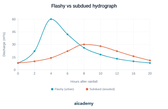
The flashy line peaks early and high (short lag time); the subdued line peaks later and lower (long lag time) because trees and permeable soils slow the water down.
| Factor | Effect on hydrograph | Why |
|---|---|---|
| Impermeable rock or soil | Shorter lag time, higher peak | Water cannot infiltrate; runs straight to river as overland flow |
| Urbanisation | Much shorter lag time, very high peak | Tarmac, concrete, and roofs are impermeable; gutters and storm drains channel water rapidly to rivers |
| Steep gradient | Shorter lag time | Water moves quickly downslope to the channel |
| Saturated soils | Shorter lag time | Soil at capacity cannot absorb more water; all rain runs off |
| Deciduous trees / vegetation | Longer lag time | Interception, transpiration, and root uptake slow water movement; roots maintain permeable soil structure |
| Sandy soils / porous rock | Longer lag time | High infiltration; water seeps slowly through soil and rock |
| Large catchment | Higher total discharge | More water collected overall, though lag time may be longer |
Something not quite clicking?
Ask Aica to explain any part of this differently. Free, takes 30 seconds.
Key terms
- Flood hydrograph
- A graph showing how river discharge changes over time in response to a rainfall event.
- Discharge
- The volume of water flowing past a point in the river per second, measured in cubic metres per second (cumecs).
- Lag time
- The time between peak rainfall and peak discharge; the shorter the lag time, the more quickly the river floods.
- Peak discharge
- The highest point of discharge reached on a flood hydrograph.
- Hard engineering
- Using constructed structures such as dams, channel straightening, flood relief channels and embankments to control or redirect river flow.
- Soft engineering
- Managing flood risk by working with natural processes, for example flood warnings, afforestation, river restoration and floodplain zoning, without large structural interventions.
- Channel straightening
- Removing meanders and deepening the channel to move water through a section faster, which can increase flood risk downstream.
- Floodplain zoning
- Restricting development to areas of low flood risk by denying planning permission for building on floodplains.
- Afforestation
- Planting trees in the upper catchment to intercept rainfall, increase infiltration and slow runoff, increasing lag time and reducing peak discharge.
- Embankments
- Artificial raised earth or concrete banks built alongside a river by engineers to increase channel capacity before overtopping.
Frequently asked questions
Lag time is the delay between peak rainfall and peak discharge, so a short lag time means the river floods quickly. Discharge is the volume of water flowing past a point per second (m3/s). A large catchment can have high discharge but a moderate lag time, so they are not the same thing.
The Boscastle flash flood on 16 August 2004 was caused by convectional thunderstorms dropping 200 mm of rain in about 5 hours onto saturated, impermeable granite catchments, funnelled into a narrow steep valley, with undersized bridges and culverts and debris blocking the bridge arch.
Hard engineering uses constructed structures to control or redirect flow, such as dams and reservoirs, channel straightening, flood relief channels and embankments. Soft engineering works with natural processes without large structures, such as flood warnings, afforestation, river restoration and floodplain zoning.
Generate revision on any topic you study
Type any topic you're studying and Aicademy generates a complete lesson, quiz, and flashcard set, personalised to your level.
Lessons on anything
Structured, level-matched lessons on any topic you study
Practice quizzes
Find out what you actually know before the exam does
Flashcard sets
Lock in key concepts with instant revision cards
Ask Aica
Stuck on something? Get a clear explanation, any time
Resource Management: Food, Water and Energy
River Processes and Landforms
Related lessons
16 min
11 min
UK Physical Landscapes: Uplands, Lowlands and River Systems
GCSE Geography · AQA 8035
4 months ago