Glacial Processes and Landforms

Aligned to the AQA 8035 specification
- Level
- Intermediate
- Reading time
- 13 min
- Published
- 10 June 2026
- Updated
- 25 August 2026
On this page
- 1.UK Ice Cover and How Glaciers Form
- 2.Glacial Processes: Weathering, Erosion, Movement and Transportation
- 3.Erosional Landforms I: Corries, Arêtes and Pyramidal Peaks
- 4.Erosional Landforms II: Glacial Troughs, Truncated Spurs, Ribbon Lakes and Hanging Valleys
- 5.Depositional Landforms: Erratics, Moraines and Drumlins
- 6.Common Exam Mistakes
Key takeaways
- During the last glacial maximum about 18,000 to 20,000 years ago, an ice sheet covered Scotland, most of Wales, Ireland and northern England, with ice up to 1,000 m thick over the Scottish Highlands.
- The two glacial erosion processes are abrasion (ice-borne debris grinds and smooths the bedrock) and plucking (the glacier freezes onto jointed rock and rips out blocks); freeze-thaw is subaerial weathering, not erosion.
- Erosional landforms include corries, arêtes, pyramidal peaks, truncated spurs, glacial troughs, ribbon lakes and hanging valleys; UK examples are Red Tarn, Striding Edge and Windermere in the Lake District.
- A corrie forms as snow accumulates in a sheltered hollow, freeze-thaw and plucking steepen the back wall, and abrasion plus rotational slip deepen the basin, leaving a tarn behind a rock lip when the ice melts.
- Depositional landforms include erratics, drumlins and four moraine types (lateral, medial, terminal, ground); till is unsorted material deposited directly by ice while outwash is sorted sediment deposited by meltwater.
Erosional Landforms I: Corries, Arêtes and Pyramidal Peaks
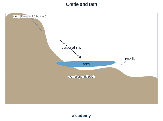
Corrie (cirque, cwm): A corrie is an armchair-shaped hollow in a mountainside, open on the downslope side and with a steep back wall and a deeper basin:
- Snow and ice accumulate in a pre-existing hollow on a sheltered (typically north or northeast facing) slope
- Freeze-thaw weathering steepens the back wall; plucking removes rock from the back and sides
- Abrasion deepens the floor of the hollow; the glacier moves by rotational slip within the hollow, maximising erosion of the floor
- A rock lip forms at the front (ablation zone, less erosion)
- When the glacier melts, a corrie lake (tarn) may form behind the rock lip
The cross-section below shows the armchair shape: a steep plucked back wall, the deepened basin worn by rotational slip, the rock lip, and the tarn left behind.
- UK examples: Red Tarn (Lake District, beneath Helvellyn), Glaslyn (beneath Snowdon, Wales)
Arête: A narrow, knife-edged ridge formed when two corries develop back-to-back on opposite sides of a mountain:
- Freeze-thaw weathering and plucking progressively narrow the ridge between the two corries
- UK example: Striding Edge (Lake District, leading to Helvellyn summit; 950 m)
Pyramidal peak (horn): Three or more corries developing around a central peak attack it from multiple sides; the residual peak becomes very sharp and pointed:
- UK example: Snowdon (Yr Wyddfa) (Wales, 1,085 m) — its summit is the remnant of corries eroding from several sides
- Classic Alpine example: the Matterhorn (Switzerland/Italy, 4,478 m)
Erosional Landforms II: Glacial Troughs, Truncated Spurs, Ribbon Lakes and Hanging Valleys
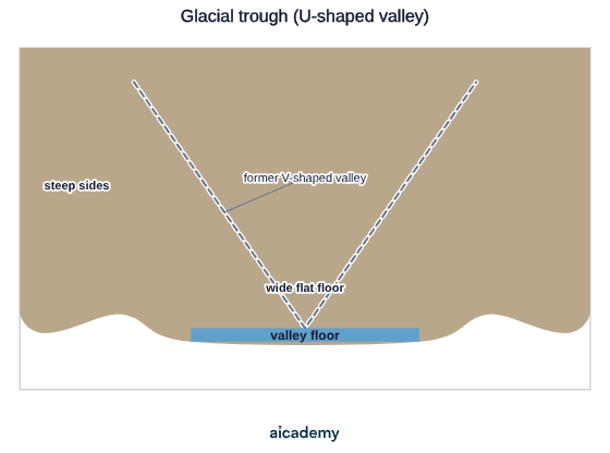
Glacial trough (U-shaped valley): A pre-glacial V-shaped river valley is transformed by glacial erosion into a wide, flat-floored, steep-sided U-shaped valley:
- The glacier fills and overflows the original valley, eroding downward and outward through abrasion and plucking
- Removes interlocking spurs (turning them into truncated spurs — cliffs cut off abruptly by ice)
- Post-glacial: the flat floor is used for farming, roads, and settlement; the steep sides remain as dramatic rock faces
- UK example: Great Langdale (Lake District); Glencoe (Scottish Highlands)
The cross-valley profile below shows the wide, flat-floored, steep-sided U-shape carved by the glacier. The dashed line marks the original V-shaped river valley before the ice arrived.
Truncated spurs: Interlocking spurs that once wound between the meanders of a pre-glacial river are cut off by the advancing glacier, leaving steep cliff faces on either side of the straightened glacial trough.
Ribbon lake: A long, narrow lake occupying the floor of a glacial trough:
- Forms where glacial erosion was particularly intense (e.g. over a patch of weaker rock, or where two glaciers merged and discharge increased)
- Deepened below sea level in some cases (over-deepening)
- UK examples: Windermere (Lake District, England's largest lake; 16.9 km long), Ullswater (Lake District), Loch Ness (Scottish Highlands; 37 km long, 230 m deep)
Hanging valley: A tributary glacier occupying a smaller side valley cannot erode as deeply as the much larger main valley glacier. When both glaciers melt, the floor of the tributary valley is left high above the main valley floor — a hanging valley. The stream now tumbles down a waterfall into the main valley below.
- UK example: Sourmilk Gill (Lake District) — a waterfall dropping from a hanging valley into the Ennerdale Valley
Want more lessons like this one?
Generate lessons on anything you study. Free account, no card needed.
Key terms
- Freeze-thaw weathering
- Subaerial weathering where water repeatedly freezes and expands in cracks in exposed rock, breaking off angular fragments that supply debris for abrasion.
- Abrasion
- Glacial erosion where angular rock fragments in the glacier's base grind against the bedrock, smoothing and deepening it.
- Plucking
- Glacial erosion where the glacier's base freezes onto jointed rock and rips out blocks as it advances, leaving a jagged surface.
- Rotational slip
- The curved, rotating movement of a glacier within a corrie or hollow that deepens the floor through abrasion.
- Corrie
- An armchair-shaped hollow eroded into a mountainside, with a steep back wall and a deepened basin, often holding a tarn behind a rock lip.
- Arête
- A narrow, knife-edged ridge formed when two corries erode back-to-back on opposite sides of a mountain.
- Pyramidal peak
- A sharp, pointed mountain summit formed where three or more corries erode a central peak from multiple sides.
- Glacial trough
- A wide, flat-floored, steep-sided U-shaped valley formed when a glacier erodes a former V-shaped river valley.
- Truncated spur
- An interlocking spur of a former river valley cut off abruptly by an advancing glacier, leaving a steep cliff face.
- Ribbon lake
- A long, narrow lake occupying the floor of a glacial trough, formed where erosion was particularly intense.
- Hanging valley
- A smaller side valley left high above the main valley floor because its tributary glacier eroded less deeply; a stream now drops from it as a waterfall.
- Erratic
- A boulder transported by a glacier and deposited far from its source, often resting on bedrock of a completely different rock type.
Frequently asked questions
Abrasion is when angular rock fragments in the glacier's base grind against the bedrock, smoothing and deepening it and producing scratches. Plucking is when the base freezes onto jointed rock and rips out blocks as it advances, leaving a jagged surface. Both happen at once but produce opposite textures.
Snow and ice accumulate in a sheltered, typically north or northeast-facing hollow. Freeze-thaw and plucking steepen the back wall while abrasion deepens the floor, and the glacier moves by rotational slip to maximise erosion. A rock lip forms at the front, and when the ice melts a tarn may form behind it.
Lateral moraine forms ridges along the sides of a glacier, medial moraine runs along the centre where two glaciers and their lateral moraines merge, terminal moraine marks the furthest extent of the glacier across the valley mouth, and ground moraine is till spread across the valley floor as the glacier retreats.
Generate revision on any topic you study
Type any topic you're studying and Aicademy generates a complete lesson, quiz, and flashcard set, personalised to your level.
Lessons on anything
Structured, level-matched lessons on any topic you study
Practice quizzes
Find out what you actually know before the exam does
Flashcard sets
Lock in key concepts with instant revision cards
Ask Aica
Stuck on something? Get a clear explanation, any time
Glacial Landscapes: Economic Activities and Conflicts
Global Development: Measuring and Comparing
Related lessons
11 min
UK Physical Landscapes: Uplands, Lowlands and River Systems
GCSE Geography · AQA 8035
4 months ago