Track progress, take quizzes and save notes on this lesson.

Free forever · no card needed

Start free
Intermediate

Glacial Landscapes: Economic Activities and Conflicts

AicademyAicademy
·GCSE Geography
3.1.3.4 Glacial landscapes in the UK

Aligned to the AQA 8035 specification

Level
Intermediate
Reading time
12 min
Published
10 June 2026
Updated
1 July 2026
On this page
  1. 1.Economic Uses of Glaciated Upland Landscapes
  2. 2.Conflicts Between Land Uses
  3. 3.Management Strategies to Resolve Conflicts
  4. 4.Case Study: The Lake District National Park
  5. 5.Conflict and Management: Windermere Speed Limit
  6. 6.Common Exam Mistakes

Key takeaways

  • UK glaciated uplands support four main economic uses: farming (hill sheep on steep sides, dairy on flat valley floors), forestry, tourism, and quarrying such as slate.
  • The Lake District receives about 19 million visitor days a year and contributes around £1.4 billion to the regional economy, but tourism also causes footpath erosion, traffic congestion and second-home price inflation.
  • Land-use conflicts include farmers versus walkers, conservationists versus foresters, and motorised water sports versus wildlife groups; a strong answer names the competing groups and their interests.
  • Management strategies include footpath pitching (the Lake District spends about £800,000 a year on path repair), park-and-ride schemes, planning controls and the Windermere speed limit.
  • The 10 mph speed limit introduced on Windermere in 2005 shows development and conservation can be balanced: reed-bed habitats partly recovered and water quality improved while non-motorised watersports tourism continued.

Economic Uses of Glaciated Upland Landscapes

UK glaciated uplands — particularly the Lake District, Snowdonia, and the Scottish Highlands — support several important economic activities. Their distinctive landscapes are both a resource and a constraint.

Farming:

  • Glacial troughs have flat, alluvial valley floors (deposited from glacial outwash): these areas are cultivated for hay and silage or support intensive dairy farming
  • Steep valley sides and upland plateaux (poor acidic soils, high rainfall, short growing season) are used for hill sheep farming (Herdwick and Swaledale breeds in the Lake District; Welsh Mountain sheep in Snowdonia)
  • Upland sheep farming supports traditional pastoral landscapes and contributes to the open moorland appearance that attracts tourists

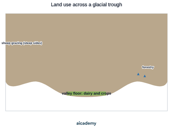
The cross-section below shows how the glacial valley's shape sorts land use: dairy and crops on the flat alluvial floor, forestry on the lower slopes, and sheep grazing on the steep upper sides.
  • Farm incomes are often low; many farms depend on agri-environment scheme payments (e.g. Higher Level Stewardship grants) to remain viable

Forestry:

  • Coniferous plantation forestry (primarily Sitka spruce and Scots pine) was developed across upland areas in the mid-20th century as part of national strategic timber reserves
  • The Forestry Commission manages significant areas in the Lake District, Border Hills, and Galloway Forest Park
  • Plantations provide timber, employment in rural areas, and carbon storage
  • Large monoculture plantations are criticised for reducing biodiversity, blocking views, acidifying streams, and being visually intrusive in open upland landscapes

Tourism:

  • The UK's glaciated uplands are primary tourism destinations
  • The Lake District receives approximately 19 million visitor days per year and contributes around £1.4 billion to the regional economy
  • Key tourism activities: walking and hiking (Wainwright's 214 fells), rock climbing and mountaineering, lake-based watersports (Windermere, Coniston), cycling, wildlife watching
  • Snowdonia (Eryri) National Park receives approximately 4.3 million visitors per year; the Snowdon Mountain Railway carries approximately 140,000 passengers to the 1,085 m summit annually
  • Tourism provides employment in accommodation, catering, guiding, and outdoor equipment retail

Quarrying:

  • Historically, slate quarrying was a major industry in North Wales (Penrhyn Quarry, Dinorwig Quarry) and the Lake District (Honister Pass, Langdale)
  • Penrhyn Quarry (Bethesda, North Wales) was once the world's largest slate quarry; at its peak in the 1890s it employed 3,000 workers and produced 130,000 tonnes of roofing slate per year
  • Today, most large quarries have ceased or reduced operations; Honister Slate Mine is now primarily a tourist attraction offering mine tours and via ferrata
  • The UNESCO Slate Landscape of Northwest Wales (designated 2021) recognises the industrial, cultural, and scenic heritage of the quarrying area — an example of development and conservation coexisting
  • Hydroelectric power generation and reservoir water supply (extra context — beyond AQA 8035 spec): Dinorwig Power Station (1,728 MW pumped-storage HEP); Thirlmere and Haweswater reservoirs (water supply for Northwest England)

Conflicts Between Land Uses

The multiple users of glaciated upland landscapes frequently have competing interests. Conflicts are most visible in the UK's National Parks, where management must balance preservation with access and economic activity.

Farmers vs tourists:

  • Walkers leaving footpaths cause soil erosion on fragile upland soils; gates left open let livestock escape; dogs disturb sheep (particularly at lambing season: March–April)
  • Increased visitor numbers bring road congestion to narrow country lanes, affecting farm vehicle movements

Conservationists vs foresters:

  • Large-scale coniferous plantations block views, reduce biodiversity of native species, acidify streams, and alter upland drainage patterns
  • However, plantation forestry provides rural employment and managed timber

Tourism operators vs environmentalists:

  • Motorised water sports (jet skis, speedboats) on Windermere create noise, wave damage to reed beds, and risk to wildlife; in 2005 a 10 mph speed limit was introduced on Windermere — resented by some tourism businesses but welcomed by wildlife groups and non-motorised watersports users
  • Overuse of popular paths causes severe erosion: the Helvellyn and Scafell Pike paths sustain hundreds of thousands of boots per year — path "braiding" (multiple parallel routes widening the erosion scar to 5–10 m in places)

Quarrying and mining vs local communities:

  • Slate quarrying and aggregate extraction create noise, dust, heavy vehicle traffic, and visual intrusion
  • Local residents and tourist businesses oppose expansion of quarrying operations

Sheep farming vs rewilding:

  • Conservation groups (e.g. Wild Ennerdale project, Trees for Life in Scotland) advocate reducing sheep numbers to allow native woodland to regenerate; upland sheep farmers oppose this as an existential threat to their livelihoods and cultural heritage

Management Strategies to Resolve Conflicts

UK glaciated uplands are predominantly managed within National Parks. The Lake District was designated a National Park in 1951 and achieved UNESCO World Heritage Site status in 2017. National Park Authorities (NPAs) use several tools to manage competing interests.

Path management:

  • Severely eroded paths are repaired using pitching (laying natural stone slabs or setts to create a firm, durable surface that withstands heavy footfall)
  • The Lake District National Park Authority spends approximately £800,000 per year on upland path repair
  • Volunteer footpath repair teams (including Fix the Fells programme) maintain high-altitude routes
  • Board walks and waymarking redirect walkers onto designated routes to limit spread of erosion

Traffic management:

  • Honeypot sites — such as Grasmere, Ambleside, and Keswick — experience severe summer traffic congestion
  • Park-and-ride schemes at Ambleside and Keswick reduce traffic entering villages
  • Promotion of cycling and the Windermere Ferry as alternatives to car travel

Water sports management:

  • The 10 mph speed limit on Windermere (introduced 2005): balances water sports access with wildlife conservation and quiet enjoyment
  • Designated zones for different activities (e.g. motorised and non-motorised zones)

Zoning and planning:

  • Strict planning controls limit new development within National Park boundaries; new buildings must use traditional materials and designs
  • No new major quarrying or industrial development is approved in core landscape zones

Sustainable tourism initiatives:

  • "Stay for a week" campaigns encourage visitors to spend longer per visit (distributing economic benefit while reducing the number of vehicles)
  • Off-peak marketing promotes quieter seasons (autumn, winter) to reduce pressure on peak summer

Case Study: The Lake District National Park

Key facts:

  • Area: 2,362 km² (England's largest National Park)
  • Designated: 1951; UNESCO World Heritage Site: 2017
  • Annual visits: approximately 19 million visitor days
  • Population within the park boundary: approximately 42,000 permanent residents

Physical base:

  • Glacially carved landscape: corrie tarns (Red Tarn, Blackmere, Bowscale Tarn), arêtes (Striding Edge, Sharp Edge), glacial troughs (Great Langdale, Borrowdale, Ullswater), ribbon lakes (Windermere, Ullswater, Coniston Water, Thirlmere, Haweswater)
  • Highest peak: Scafell Pike (978 m) — England's highest mountain

Economic activities and their tensions:

ActivityBenefitConflict / Challenge
Hill sheep farming (Herdwick)Traditional landscape management; supports biodiversity of open fell; farm incomeLow profitability; dependence on subsidies; rewilding debates threaten this land use
Tourism£1.4 billion/year; 18,000 jobs in the wider economyTraffic congestion; footpath erosion; second-home ownership drives up house prices, reducing affordability for locals
Water supply reservoirs (Thirlmere, Haweswater)Water for Northwest EnglandFlooded two villages (Mardale Green, drowned under Haweswater, 1937); limited public access on reservoir catchment land
Forestry (Grizedale Forest, Whinlatter)Timber; recreation (mountain biking, zip lines); habitat for red squirrelsHistoric criticisms of view-blocking monoculture; older plantations being diversified with native broadleaf

Something not quite clicking?

Ask Aica to explain any part of this differently. Free, takes 30 seconds.

Ask Aica

Conflict and Management: Windermere Speed Limit

The introduction of a 10 mph speed limit on Windermere in 2005 illustrates how conflicts between development and conservation are managed in a National Park.

The conflict:

GroupPositionReason
Motorised watersports users and hire businessesOpposed the limitClaimed loss of livelihood; argued Windermere's size was sufficient to accommodate fast boats
Wildlife conservation organisations (RSPB, Lake District National Park Authority)Supported the limitSpeedboats caused wave damage to reed-bed habitats of breeding birds (including great crested grebe); oil pollution risk; noise disruption
Non-motorised watersports users (kayakers, sailors, rowers, swimmers)Supported the limitSafety risk from fast craft; noise; wake destabilised small vessels
Lakeside residentsMajority supported the limitNoise, reduced water quality, and amenity impacts

The management decision: After years of consultation, the Lake District National Park Authority introduced the 10 mph limit in March 2005, covering the entire 16.9 km length of Windermere — the first speed limit on a natural lake in England.

Outcomes:

  • Reed-bed habitats have partially recovered since 2005
  • Shoreline erosion from boat wake has been reduced
  • Water quality has improved
  • Watersports tourism continues in non-motorised forms (kayaking, paddleboarding, sailing have grown)
  • Motorised watersports providers that claimed losses ultimately relocated to other lakes or diversified

This case illustrates that development and conservation can be balanced through regulation — the economic function of tourism was maintained while conservation objectives were met.

Common Exam Mistakes

1. Treating tourism as only positive

Tourism brings economic benefits but also causes footpath erosion, traffic congestion, second-home price inflation, and noise. A complete answer presents both economic benefits (employment, income, supporting local businesses) and environmental/social costs.

2. Describing conflicts without naming the groups involved

A conflict answer must name the competing groups: "farmers and walkers" or "tourism businesses and wildlife conservation organisations" — not just "people disagree." Naming stakeholders and their specific interests demonstrates understanding of the conflict.

3. Forgetting that farming is a major land use alongside tourism

Many students focus exclusively on tourism when answering questions about glaciated upland economic activities. The spec requires farming, forestry, tourism, and quarrying. In an extended answer, cover all four land uses before discussing conflicts.

4. Mixing up physical and human geography in glaciation questions

Some questions ask about physical processes and landforms; others ask about human uses and management. Check the question carefully. Describing corries and arêtes when asked about land-use conflicts will not earn marks, however accurate the physical geography is.

5. Failing to link the physical landscape to the economic activities

The strongest answers show the connection: "the flat alluvial floor of the glacial trough is used for dairy farming, while the steep valley sides above support hill sheep grazing." The physical landscape determines which economic activities are viable — examiners reward this integration.

Key terms

Glacial trough
A wide, flat-floored, steep-sided U-shaped valley carved by a glacier, whose flat alluvial floor is used for dairy farming and crops.
Hill sheep farming
Grazing hardy sheep breeds such as Herdwick and Swaledale on steep valley sides and upland plateaux with poor acidic soils and short growing seasons.
Honeypot site
A popular tourist location, such as Grasmere, Ambleside or Keswick, that attracts large numbers of visitors and suffers severe congestion.
Pitching
Laying natural stone slabs or setts to create a firm, durable path surface that withstands heavy footfall and reduces erosion.
Rewilding
Reducing land-use pressures such as sheep grazing to allow native woodland and ecosystems to regenerate.
National Park
A protected area, such as the Lake District (designated 1951), where management balances conservation with public access and economic activity.

Frequently asked questions

Farming (hill sheep on steep upper slopes and dairy or crops on the flat alluvial valley floor), forestry (coniferous plantations such as Sitka spruce), tourism (walking, climbing and watersports), and quarrying (historically slate in North Wales and the Lake District). The spec requires all four.

The Lake District National Park Authority introduced a 10 mph limit on Windermere in March 2005 because speedboats caused wave damage to reed-bed bird habitats, oil pollution risk, noise, and safety risks to non-motorised users. Since then reed beds have partly recovered and water quality has improved.

National Park Authorities repair eroded paths by pitching with stone slabs, run park-and-ride schemes at honeypot sites like Ambleside and Keswick, set water-sports speed limits and zones, apply strict planning controls, and promote sustainable tourism such as stay-for-a-week and off-peak campaigns.

Generate revision on any topic you study

Type any topic you're studying and Aicademy generates a complete lesson, quiz, and flashcard set, personalised to your level.

Lessons on anything

Structured, level-matched lessons on any topic you study

Practice quizzes

Find out what you actually know before the exam does

Flashcard sets

Lock in key concepts with instant revision cards

Ask Aica

Stuck on something? Get a clear explanation, any time

Prev

Geography Exam Technique: Command Words and Extended Writing

Next

Glacial Processes and Landforms

Related lessons

Top students don’t revise more. They revise what counts.

Start revising free

Free to start. No card needed.