Track progress, take quizzes and save notes on this lesson.

Free forever · no card needed

Start free
Intermediate

Tropical Storms: Formation, Structure and Effects

AicademyAicademy
·GCSE Geography
3.1.1.3 Weather hazards

Aligned to the AQA 8035 specification

Level
Intermediate
Reading time
13 min
Published
10 June 2026
Updated
1 July 2026
On this page
  1. 1.Global Atmospheric Circulation
  2. 2.Where and Why Tropical Storms Form
  3. 3.How a Tropical Storm Develops
  4. 4.The Structure of a Tropical Storm
  5. 5.Case Study: Typhoon Haiyan, 2013
  6. 6.Managing Tropical Storms: Monitoring, Prediction, Protection and Planning
  7. 7.Tropical Storms and Climate Change
  8. 8.Common Exam Mistakes

Key takeaways

  • Tropical storms form only where three conditions are met together: sea surface temperature above 26C, a latitude of 5-20 degrees so the Coriolis effect can spin the system, and low wind shear.
  • The eyewall, not the eye, is the most dangerous part: the eye is a calm, clear region 20-50 km across, while the violent eyewall has the strongest winds (up to 315 km/h), heaviest rain and greatest storm surge.
  • Storm surge is a temporary rise in sea level from low pressure and onshore winds and is distinct from rainfall flooding; the 5-8 m surge, not the wind, caused most deaths in Typhoon Haiyan (2013).
  • Latent heat released as water vapour condenses is the central energy mechanism, driving a positive feedback loop that intensifies the storm while sea temperatures stay above 26C and wind shear stays low.
  • Climate change is expected to make tropical storms stronger and shift their distribution rather than simply more frequent: the total number may not rise, but the proportion reaching categories 4 and 5 should increase.

Global Atmospheric Circulation

All weather, including tropical storms, is driven by differences in solar heating across Earth's surface. The general circulation model explains these patterns.

The atmosphere organises into three circulation cells per hemisphere:

CellLocationWhat happens
Hadley cell0°–30°Intense solar heating near the equator drives warm air up. It flows poleward, cools, and sinks around 30°N/S. Creates low pressure at the equator (ITCZ) and subtropical high pressure at 30°.
Ferrel cell30°–60°An indirect cell driven by the Hadley and Polar cells on either side. Sinking air at 30° and rising air at 60°.
Polar cell60°–90°Cold, dense air sinks at the poles and flows equatorward, rising near 60°. Creates polar high pressure and a subpolar low at 60°.

Surface winds blow from high pressure toward low pressure:

  • Trade winds: blow from subtropical highs (~30°) toward the equatorial low; they converge at the ITCZ and steer tropical storms in the tropics
  • Westerlies: blow from subtropical highs toward the poles in mid-latitudes

The ITCZ (Inter-Tropical Convergence Zone) — the band of intense low pressure near the equator where trade winds from both hemispheres meet — is where the energy conditions for tropical storm formation concentrate.

Where and Why Tropical Storms Form

Tropical storms form only where three conditions are simultaneously met:

1. Sea surface temperature above 26°C (to a depth of ~50 m): Warm ocean water is the fuel. It heats the air above it, causing rapid evaporation and the rise of warm, moist air. Storms weaken or die when they cross cooler water.

2. Latitude between 5° and 20°: The Coriolis effect — caused by Earth's rotation — must be strong enough to spin the rising air into a rotating system. The Coriolis effect is zero at the equator, which is why tropical storms almost never form within 5° of it.

3. Low wind shear: Strong upper-level winds blowing at a different speed or direction from surface winds would tear the developing storm structure apart before it can organise.

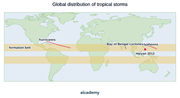
RegionName usedPeak season
North Atlantic and CaribbeanHurricaneJune–November
Western Pacific (east of the Philippines)TyphoonApril–December
Indian Ocean and Bay of BengalTropical cycloneNovember–April (Southern Hemisphere)

The same phenomenon, three names — all dependent on warm tropical ocean water.

The map below shows the main storm basins and the formation belts roughly 5–20° north and south of the equator, where sea temperatures and the Coriolis effect are both sufficient.
How a Tropical Storm Develops

Formation follows a sequence driven by a positive feedback loop:

  1. Intense solar heating warms the ocean surface. Warm, moist air rises rapidly, creating a low pressure system at the surface.
  2. Air from surrounding areas rushes in to fill the low pressure. The Coriolis effect causes this inward-flowing air to spiral — anticlockwise in the Northern Hemisphere, clockwise in the Southern.
  3. The rising, spiralling air cools as it ascends. Water vapour condenses into towering cumulonimbus clouds and intense rainfall.
  4. Condensation releases latent heat — the energy stored when water evaporated from the ocean surface. This warms the surrounding air, making it rise faster, drawing in more warm, moist air at the surface.
  5. This feedback intensifies the storm as long as sea temperatures remain above 26°C and wind shear stays low.
  6. The storm weakens when it moves over cooler water, reaches land (cutting off the ocean moisture supply), or encounters high wind shear.

The release of latent heat is the central energy mechanism. A large tropical storm releases as much energy in a day as thousands of nuclear bombs.

The Structure of a Tropical Storm

A mature tropical storm has a characteristic structure that can be identified on radar and satellite imagery. The cross-section below shows the calm central eye, the violent eyewall either side of it, and the spiral rainbands fanning outward.
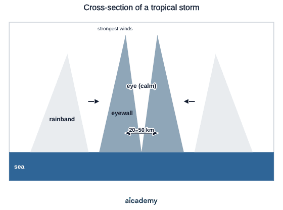
The eye: A calm, roughly circular region 20–50 km across at the storm's centre. Warm sinking air, clear or partly cloudy skies, low pressure at the surface. Counterintuitively, the eye is the calmest part of the storm — a critical exam point.

The eyewall: The ring of intense convective cloud surrounding the eye. The most violent part of the storm: the strongest winds (up to 315 km/h in the most powerful storms), the heaviest rainfall, and the greatest storm surge threat. Most deaths in tropical storms occur in or near the eyewall and its associated storm surge.

Spiral rainbands: Bands of cloud and thunderstorms spiralling outward from the eyewall. Heavy rain and gusty winds extend hundreds of kilometres from the centre, causing widespread flooding even in areas that experience only the outer edge of a storm.

Hazards:

  • High winds: structural damage to buildings, uprooted trees, flattened crops, downed power lines
  • Heavy rainfall: inland flooding, river flooding, landslides on saturated slopes
  • Storm surge: a temporary rise in sea level driven by low pressure and onshore winds — often the most lethal component, capable of reaching 5–8 metres above normal sea level

Something not quite clicking?

Ask Aica to explain any part of this differently. Free, takes 30 seconds.

Ask Aica

Case Study: Typhoon Haiyan, 2013

8 November 2013 | Philippines | Category 5 Super Typhoon | Peak winds: ~315 km/h

Typhoon Haiyan (called Yolanda locally) is one of the most powerful tropical storms ever recorded at landfall.

Causes of its intensity: Sea surface temperatures in the western Pacific were significantly above average (>29°C). Exceptionally low wind shear allowed Haiyan to maintain its structure and intensify to maximum strength just before hitting land.

Primary effects:

  • Storm surge of 5–8 metres inundated Tacloban City and coastal areas of Leyte Island — the surge, not wind, caused most deaths
  • 6,300+ deaths; approximately 1,800 still officially listed as missing
  • 1.1 million homes damaged or destroyed; over 4 million people displaced
  • Tacloban (population ~220,000) almost completely destroyed

Secondary effects:

  • Widespread food and water shortages in the immediate aftermath; looting reported
  • Disease risk from contaminated water supplies
  • Schools used as emergency shelters for months; education severely disrupted
  • Estimated total economic damage: $2.8 billion

Responses:

  • The Philippine government declared a state of national calamity within 24 hours
  • Over 60 countries sent aid; the USA deployed aircraft carrier USS George Washington with helicopters for supply distribution
  • A critical lesson emerged: the official storm surge warning system had focused on wind speed, not surge height — many residents did not understand the scale of flooding risk. The Philippines has since improved storm surge communication.

Managing Tropical Storms: Monitoring, Prediction, Protection and Planning

The same four-strategy framework used for tectonic hazards applies to tropical storms. The critical difference is that tropical storms can be tracked for days before landfall — giving management systems more warning time than earthquakes typically allow.

Monitoring:

  • Weather satellites track storm position, movement, and intensity continuously. Geostationary satellites provide real-time imagery; polar-orbiting satellites measure wind speeds and sea surface temperatures precisely.
  • Hurricane hunter aircraft fly directly into tropical storms, dropping instrument packages (dropsondes) to measure pressure, wind speed, and temperature inside the storm — data satellites cannot replicate.
  • Ocean buoys and ships monitor sea surface temperatures, wave heights, and atmospheric pressure, confirming whether intensification conditions are present.

Prediction:

  • Storm track forecasting: meteorological agencies (the US National Hurricane Center; Japan Meteorological Agency) issue forecast cones showing the probable track over 3–5 days. Track forecasting has improved substantially since the 1990s.
  • Storm surge modelling: numerical models calculate expected sea level rise at coastal points given a storm's projected track — critical for targeted surge warnings.
  • Intensity forecasting remains harder: rapid intensification (strengthening by 35+ knots in 24 hours) is difficult to predict and has been responsible for several catastrophic surprises at landfall.

Protection (reducing vulnerability before a storm arrives):

  • Storm shelters: purpose-built reinforced cyclone shelters across Bangladesh and the Philippines have dramatically reduced deaths. Bangladesh cut cyclone fatalities by over 95% between the 1970 Bhola cyclone (~300,000 deaths) and comparable later events.
  • Coastal defences: sea walls, storm barriers, and mangrove restoration reduce storm surge inundation. Mangroves in particular provide a natural buffer requiring no maintenance.
  • Building codes: homes and public buildings designed to withstand high winds, with anchored roofs and elevated floor levels in surge-prone areas.

Planning:

  • Evacuation procedures: pre-planned mass evacuation routes, with government transport for those without vehicles. The Philippines evacuated ~800,000 people before Typhoon Haiyan — many who died had not understood the storm surge risk specifically.
  • Public warning systems: multi-channel alerts (SMS, radio, sirens, community officials) to reach those without internet access.
  • Education and drills: community exercises rehearse the response to warnings. A key lesson from Haiyan: residents understood wind-speed warnings but had no mental model of storm surge depth — subsequent public education specifically addressed this gap.
  • Land-use planning: no-build zones within storm surge reach; critical infrastructure located away from the most exposed coastal areas.

AQA questions on tropical storm management expect recognition of all four categories. A strong answer links each strategy to a specific impact it reduces — not just a list of names.

Tropical Storms and Climate Change

Climate change is altering the conditions under which tropical storms form and intensify. The projections are more nuanced than simply "more storms":

Warmer sea surface temperatures: As average ocean temperatures rise, more ocean area exceeds the 26°C threshold. This means storms can form in areas that were previously too cool and can intensify more rapidly before landfall.

Sea level rise: Even without any change in storm intensity, a higher baseline sea level means storm surges travel further inland and flood more deeply. A 0.5 m rise in mean sea level can roughly double the land area inundated by a given storm surge height.

Changing distribution: Some modelling suggests tropical storms will increasingly track into mid-latitude areas — including parts of the Mediterranean, eastern China coast, and potentially southern Japan — that currently experience very few or none.

Frequency vs intensity: The total number of tropical storms per year may not increase — it may even decrease slightly. But the proportion reaching the highest intensity categories (4 and 5) is projected to increase significantly. Fewer storms, but more of the worst kind.

AQA exams regularly ask: "Explain how climate change might affect tropical storms." The key ideas are intensity (stronger due to warmer seas) and distribution (potentially affecting new areas). Stating simply "there will be more storms" is not accurate — the evidence points to fewer but stronger events.

Common Exam Mistakes

1. Saying the eye of a storm is the most dangerous part

The eyewall is the most violent part of a tropical storm. The eye is deceptively calm — a well-known hazard is that people who shelter as the eye passes overhead may think the storm is over, leave their refuge, and be struck by the returning eyewall winds from the opposite direction.

2. Confusing storm surge with flooding from rainfall

A storm surge is a temporary rise in sea level caused by the combination of low atmospheric pressure (which allows sea level to rise) and powerful onshore winds pushing water toward the coast. It is distinct from inland flooding caused by heavy rainfall. The storm surge was responsible for most deaths in Typhoon Haiyan; understanding this distinction affects how you explain responses and management.

3. Answering "effects" questions with only deaths

Effects should be structured across three categories: social (deaths, displacement, health, education), economic (damage to buildings, businesses, infrastructure, loss of income), environmental (erosion, habitat destruction, crop damage, soil degradation). An answer that only lists deaths is unlikely to exceed Level 1 for a "describe the effects" question.

4. Describing the Coriolis effect as "the storm spinning"

The Coriolis effect is not a force that spins the storm directly. It deflects moving air to the right in the Northern Hemisphere and to the left in the Southern, causing inward-flowing air to curve into a spiral. The storm rotates as a consequence of this deflection. The distinction matters if asked to explain the Coriolis effect specifically.

5. Stating that tropical storms only affect poorer countries

Typhoon Haiyan hit the Philippines (an NEE). Hurricane Katrina (2005) struck the United States (a HIC), killing 1,800 people and causing 125 billion in damage in Texas. All countries in tropical storm zones are vulnerable; the difference lies in mortality rates and recovery speed, not immunity to the hazard.

Key terms

ITCZ (Inter-Tropical Convergence Zone)
The band of intense low pressure near the equator where trade winds from both hemispheres meet, where the energy conditions for tropical storm formation concentrate.
Coriolis effect
The deflection of moving air caused by Earth's rotation, to the right in the Northern Hemisphere and left in the Southern, which curves inward-flowing air into a spiral; it is zero at the equator.
Wind shear
A difference in speed or direction between upper-level and surface winds; strong wind shear tears a developing storm apart, so low wind shear is needed for formation.
Latent heat
The energy stored when water evaporated from the ocean and released when water vapour condenses, warming the air and driving the storm's intensifying feedback loop.
Eye
The calm, roughly circular region 20-50 km across at the centre of a tropical storm, with warm sinking air and clear skies.
Eyewall
The ring of intense convective cloud surrounding the eye; the most violent part of the storm with the strongest winds, heaviest rain and greatest storm surge threat.
Spiral rainbands
Bands of cloud and thunderstorms spiralling outward from the eyewall, bringing heavy rain and gusty winds hundreds of kilometres from the centre.
Storm surge
A temporary rise in sea level driven by low pressure and onshore winds, often the most lethal part of a storm, capable of reaching 5-8 metres above normal sea level.
Trade winds
Winds that blow from the subtropical highs near 30 degrees toward the equatorial low, converging at the ITCZ and steering tropical storms in the tropics.

Frequently asked questions

A tropical storm needs three conditions at once: a sea surface temperature above 26C to a depth of about 50 m to provide the energy, a latitude between 5 and 20 degrees so the Coriolis effect is strong enough to spin the rising air, and low wind shear so strong upper-level winds do not tear the developing storm apart.

The eye is a calm, roughly circular region 20-50 km across at the storm's centre, with warm sinking air and clear or partly cloudy skies. The surrounding eyewall is the most violent part, so a known hazard is that people may think the storm is over as the eye passes and then be struck by the returning eyewall winds.

Climate change is expected to make storms more intense and shift their distribution, not simply produce more of them. Warmer seas let storms form over more ocean and intensify faster, sea level rise makes surges reach further inland, and the proportion reaching categories 4 and 5 should rise even if the total does not.

Generate revision on any topic you study

Type any topic you're studying and Aicademy generates a complete lesson, quiz, and flashcard set, personalised to your level.

Lessons on anything

Structured, level-matched lessons on any topic you study

Practice quizzes

Find out what you actually know before the exam does

Flashcard sets

Lock in key concepts with instant revision cards

Ask Aica

Stuck on something? Get a clear explanation, any time

Prev

Tectonic Hazards: Effects, Responses and Management

Next

UK Weather Hazards and Extreme Weather

Related lessons

Top students don’t revise more. They revise what counts.

Start revising free

Free to start. No card needed.